People rushing towards the boat as it is docked on a good day.

Weather information and livelihoods in Mafia Island

Fasco Chengula (University of Roehampton PhD Student)

Fasco Chengula (PhD research student, University of Roehampton) in the Field in Mafia Island, Tanzania

Having completed all the administrative logistics and research clearance from relevant authorities, I finally arrived in Mafia archipelago, one of the most important Indian Ocean ancient trading networks, scattered over the Indian Ocean 21 km off the Rufiji River Delta in central Tanzania, home to whale sharks, ancient Swahili city ruins of Kua, Chole and Kisimani Mafia as well as a world class scuba and snorkeling diving center.  I had an opportunity to introduce myself and the research I am doing to the Mafia District Commissioner (DC), District Administrative Secretary (DAS), and District Executive Director (DED) and met a number of stakeholders relevant to my research: heads of Department at Mafia District Council (e.g. Fisheries officer, Community Development officer, Land officer, Natural resource and environment officer, Tourism officer and Agricultural officers); Mafia Marine Park;  Kua Ancient Swahili town conservation society; Mafia Airport Meteorological section; Mafia Island Lodge Diving centre (great users of weather data for diving excursion) ; Fishing  groups in Kilindoni town and Jibondo Island and women fishing groups.

Plate 2: A view of Kilindoni Port, Mafia Island as you Land down at the Mafia Airport. Photo by Fasco Chengula

Plate 3: Whale sharks are a popular tourist attraction in Mafia, and a contributor to local economy and, revenue for Mafia District Council. To see this incredible marine mammal, you must consult local fishermen who possess enormous local ecological knowledge of the ocean and its bio-physical resources. Photo by Fasco Chengula

Plate 4: King of Kua remains of a double storied palace at the Ancient Kua Swahili city ruins in Juani Island, Mafia. Photos: Fasco Chengula

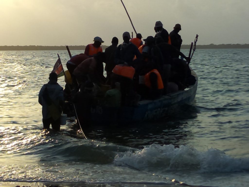
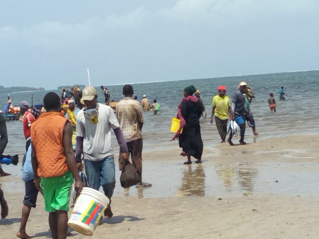
Small-scale rustic fisheries activities are a strong component of the local livelihoods and economy in the Island. Small scale farming (food and cash crops such as rice and coconuts respectively), tourism, small business activities and livestock keeping are also practiced. Mafia islands are also known for boat building which is justly famous throughout East Africa, with hand tools and hand-forged nails to create the jahazis, dhows, mashuas and ngalawas you will see in Mafia.

Mafia’s weather and oceanic conditions exhibit certain features that are unique to Coastal Tanzania and East Africa. Being highly influenced by trade wind systems (Northeast monsoon December to April, and southeast monsoon June to October) and pronounced moisture convergence in Indian Ocean sea breezes, Mafia Archipelago is the highest receiver of rainfall in coastal Tanzania

The lunar cycle, not only controls fishing schedules, but also influences most of the tourist activities (diving excursions to experience marine life such as swimming along with whale shark/ school of whale sharks, shoals of fish, turtles  and coral life). Weather information not only helps tour guides (boatmen) to truck marine organisms that are of interests to tourists and obtain the best visibility for their guests but also to avoid strong currents and ensure safety.

Plate 5: Top, Fishermen preparing fishing nets and boats for night fishing; Bottom, fishermen offloading fish/landing from day fishing.

Movements from one island to another in Mafia can only be done using rustic boats, and dhows whose operations and schedules is depend on weather and tides. Swahili phrases such as “Bahari/ pwani ikiwa shwari, in shaa Allah” (in case the ocean is calm, God willing) are common phrases you can hear when people conclude a plan/agreement of activity schedule for the next day. The Kua Ruins in Juani Island extending over more than 40 acres with a large double storied palace is an archaeological site from the 12th Century, established by settlers from Kilwa can be accessed by boat across the Bay from Utende only during the high tides.  The Kua Ancient town preservation Society formed by residents of Juani Island are the only certified local tour guides who stays at the entrance gate close to the boat landing site to receive guests only when its high tide. “We do not expect visitors during low tide, since the tides are not predictable; we depend on information from experienced fishers’ fishing around the area” said the Kua Ancient town preservation Society chair when I visited the site.

At the far south-western tip of Mafia, is the Kisimani Mafia, a submerged old town. Most of its ruins are highly susceptible to ocean wave erosion whose strength, magnitude and frequency is believed to have increased over the recent years due to rising sea level.

Plate 6: Still Standing (top) and almost gone (bottom) water well ruins along the beach of Kisimani Mafia ancient town whose part is said to have been submerged.

Plate 7: Water well built in the times of yore of the Kisimani Mafia ancient town which Still in use today by the local community.

The focus of this study is to explore and document ethnography of the intangible marine local and indigenous knowledge heritage of weather forecasting (LIKS) among fishing communities in Mafia Island, and to investigate their role in strengthening coastal rural livelihoods amidst changing climate in Tanzania. This research is being conducted at a time when LIKS in weather and climate is lacking in the scientific literature, and highly needed to inform international policy processes. This study is also at the core of the intangible marine cultural heritage for which the UNESCO’s Local and Indigenous Knowledge Systems Programme (LINKS) was established in 2002. Coming blogs will feature how local fishers in Mafia Island predict weather using knowledge acquired through years of experience in interacting with the ocean.

People rushing towards the boat as it is docked on a good day.

Sensing the Marine Environment: Everyday experiences of a fishing community

Victor Alati (University of Roehampton PhD Student)

I am conducting my fieldwork at Gazi – a fishing village located about 60 km south of Mombasa along the Kenyan coast. Gazi is one of the major fish-landing sites along the Kenyan coast. It is mostly known for its efforts in the conservation and restoration of mangrove resources. There are over 200 fishers deriving their livelihood from the sea. Fishing gears predominantly being used include: ringnets, gillnets, handlines, spearguns and basket traps.

My study aims to utilize ethnographic approaches to understand fisher’s sociocultural experiences, practices, beliefs, opinions, moralities, values, identities and way of life through identifying their sensory categories and meanings and to test these existing approaches. It will mainly rely on participant observation and interviews with fishers to produce day-by-day written, descriptive details that are part of fishers’ daily round of life.

Ringnet fishers preparing to go fishing early in the morning

Figure 1:Ringnet fishers preparing to go fishing early in the morning. Each ringnet crew comprises of about 30 fishermen.

My observations each day begin very early in the morning at the beach as fishers prepare to leave. By midday, fishers begin to return from fishing grounds with the catch. The fish are weighed and then sold to fish traders.

On a good day, ringnet fishers can land tonnes of fish. Fishers make phone calls to fish traders and community members while at sea to inform them about the good catch. Everyone in the village is overjoyed when large quantities of fish are landed. At the beach, large numbers of fish traders and community members are observed eagerly waiting for the boat to dock. Children are also seen playing at the beach. When the boats dock, people are seen rushing towards the fishers to welcome them back.

People rushing towards the boat as it is docked on a good day.

Fig. 2: People rushing towards the boat as it is docked on a good day. On this particular day, over 100 kg of fish was given out free of charge to the community members to celebrate the bumper harvest.

Since there are currently no storage facilities at the landing site, all the landed fish is sold while still fresh. “On a good day like this one, the smell of fish lingers all over the village!” says one of the fishers. “We give extra fish free of charge to community members who flock to the beach to welcome us back. Nearly every household gets a share of the catch,” he added.

On a bad day, however, few fish traders can be seen standing at the beach looking dejected. Most community members are normally not observed at the beach. Bad days frequently occur during the southeast monsoon season. “Good days occur during the northeast monsoon season, which begins this September,” another fisher says.

Fish traders are leaving the beach with empty buckets on a bad day.

Fig. 3: Fish traders are leaving the beach with empty buckets on a bad day.

Through participant observation, I expect to establish relationships with fishers based on rapport and trust. This will enable me to carry out my research more effectively. I plan to accompany some of the fishers in fishing trips from October 2019 to understand fishing experience and culture.

The people of the sea will connect you to the world more than the Island internet!

Monicah Sairo (University of Roehampton PhD Student)

Karibu Lamu Tamu’ (welcome to sweet Lamu) was the first phrase that attracted my attention as a researcher when I first landed on the historic Island. Captain Bakari had said this to me while inviting me onboard his small beautiful dhow.  ‘The sweetness of the Island is in the ocean’, said Bakari. After a lengthy chat Bakari concluded by reiterating that he and his family have depended on the sea for years. Unfortunately, my journey was only half an hour and hence, I did not get to delve further into the exciting conversation.  However, the encounter with Bakari, and the chit-chat on my way to my hotel, prepared me to confront such ‘pregnant’ statements.  As I began to understand the uses of sayings and symbols seems to be part of the everyday conversation among the Lamu people.

Monicah waiting for the captain, traditional dhow

At one point, on my way to the hotel, Captain Bakari, suggested a few things to do in the Island as a tourist but explaining to him who I was he was quick to recommend things I should do as a student and or a Nairobian who studies in London. My position and different personas were the second things that I had to grapple with, being a young woman, an outsider, a student from the UK, a Kenyan, a Maasai all these personas in one way or the other have on many occasions influenced the varied relationships. I have begun to develop. My identity as Maasai woman on the Island in most instances becomes the entry point of long candid conversations. However, most reactions mostly depended on my response to questions such as, “Which part of Kenya are you from?”, “Is this your first time in Lamu?” or “How long will you be here for?”  Although these were very common questions in my first week in the Island, I must admit that I now begin to feel part of the society. I have been invited to attend youth activities such as the Youth Dialogue Forum and the Art of Breathing Talk, among others. Through this conversations, I, have been able to develop contacts with different artists/artisan and craftspeople on the Island. Furthermore, I have been able to expand my research contacts mainly through recommendations from the different people that I meet, in different social spaces, such as eateries, museum, art and crafts studios and youth creative spaces among others.

Monicah at a youth creative space in Lamu

Having been on the Island 7 years ago, I couldn’t help noting the obvious changes around the ocean. The ocean is a constant point around which my activities circulate but also there were changes such as the use of new fiberglass boats, motorcycles, and the unavoidable sight of pollution along the beaches. The new boats and motorcycles seem to be part of the main transport around and within the Lamu Archipelago which complement, and in some areas, have replaced the traditional dhows and donkeys. Walking between some Islands such as Lamu and Shela, one is constantly forced to give way to the motorbikes, and this seems to be the trigger to chit-chats between the pedestrians. One man, riding a donkey, said to me, ‘I hate to admit that these bikes are a nuisance but a blessing to the youth, it is a source of employment’. Another pedestrian joined in the conversation and was quick to give his opinion, ‘I think they are dangerous, not many of the riders are professionally trained, and they have caused a lot of unrecorded accidents’.

One captain of a traditional dhow said to me, ‘New boats are saviours to many but sadly come with a cost…..many people have opted for these boats because of cost of making and maintaining them. However, they are not as comfortable as the traditional dhows and in addition they have contributed to pollution of the sea.’

sdr

This is just an excerpt of how my everyday life in Lamu is developing. The Lamunian are very friendly, engaging and curious people, this has made it easy for me as a researcher to search for information. However, the amount of information from everyday engagements has been overwhelming.

Needless to say, the Island’s enthralling history, intimate alleyways, deserted beaches and slow pace of life captivates travellers and this will often stir up exciting conversations.  ‘This is an insanely happy place’, said a female tourist who was ending her visit. She smiled ruefully as the boat man replied to her, “Leaving the Island is a disease, to come back is the cure’.

The controversy of the Lamu Coal Power Station, Kenya

Wycliffe Omondi 

The scramble for Africa’s abundant, unexploited minerals and natural resources has of late invited a new scramble by powers from within and without the continent. These new trends, especially along the coast of East Africa, are closely linked with oil and gas prospecting industries, major seaports’ and road network constructions which are stipulated to bring development to East Africa and Kenya in particular. However, more often such development projects may also be potential threats to the rich marine cultural heritage if not well planned.

Ever since I started working in the heritage sector I have always been fascinated by the antagonistic relationships between cultural heritage conservation and development. Coincidentally, I am currently a PhD candidate at the University of Nottingham where my research focuses on the critical examination and analysis of cultural heritage conservation as a driver for local community sustainable development with specific reference sites along the Kenya coast.

One area that has of late attracted major infrastructural development in Kenya is Lamu archipelago located on the northern coast of Kenya. The area has been earmarked as the convergence point for a US$29.2 billion Lapsset (Lamu Port South Sudan Ethiopia Transport) Corridor program by the Government of Kenya (GoK). The archipelago is a system of six inhabited islands that are closely interconnected not only with the Islands but also with the surrounding environment including the mainland, in terms of fishing grounds, culture, family ties, mangrove forests and farmlands.

The Lapsset program has several components including the development of a seaport with 32 deep sea berths at Manda Bay (three berths are currently under construction), a standard gauge railway line to Juba and Addis Ababa, a road network, oil pipelines to and from South Sudan and Ethiopia, an oil refinery, three international airports and three resort cities at Lamu, Isiolo and Lake Turkana shores corridor. This program is part of the Government of Kenya’s national development strategy Vision 2030 economic pillar which aims at transforming Kenya into an industrialized middle income country providing a high quality of life to all its citizens by 2030 in a “clean and secure environment.”

Controversially, a coal power plant, Lamu Coal Power Station (LCPS), is to be developed in order to operate as part of Lapsset. Alongside the development of Lamu Port, resorts and the oil pipelines this power station is envisaged as one of the key catalysts in the development of Lamu. It must be built to provide electricity to make the development and subsequent habitation possible.

Coal Development site in Lamu Kenya

The proposed LCPS is located on the mainland near Lamu Island’s Old Town – a Unesco World Heritage site. The Old Town is considered one of the oldest and best preserved living Swahili towns whose golden age is believed to have been the period between 17th century and 19th century under Omani control. Inscription of Lamu Old Town into Unesco’s World Heritage List in 2001 was due to its architecture and urban structures that reveal the interaction of cultural influences of Africa, Asia and Europe over centuries to produce a distinctive Swahili culture. In addition it is considered a significant centre for the study of Islamic and Swahili cultures. A traditional function it has retained for centuries up to date.

Coast of Lamu Kenya

Due to the fragile nature of Lamu’s environment and culture, concerns were raised by local community members and NGOs’ such as Save LamuNatural Justice and Katiba Institute on the potential irreversible changes on the delicate natural environment and rapid disruption of the towns cultural traditions which forms an integral part of Lamu identity.

Despite local opposition to the coal power plant, the Government of Kenya awarded Amu Power Company (APC) the development rights in September 2014 (deal valued at approximately US$2 billion). APC is a consortium of Centum Investments Company Limited (a Kenyan private equity firm), Gulf Energy (a Kenyan energy generating company) and Sichuan Electric Power Design and Consulting Company Limited (SEDC) which is a subsidiary of Power Construction Corporation of China (Power China). Subsequently in mid- 2017, a 25 year Power purchase agreement between Lamu Coal Power Station with the investor Amu power, was singed in China witnessed by the President of Kenya, with guarantee from African Development Bank, even though the project is a private investment. “The President’s presence at the signing was likely arranged by the promoters of the project to shore up support for it,” according to David Ndii (2017), a Kenyan Daily Nation Newspaper columnist. However, the construction has repeatedly been halted due to opposition by environmentalists and human rights groups, for the plant will lead to air pollution, destruction of mangroves and breeding grounds for endangered species of marine turtles, fish and other marine life. The latest suspension of the project is a decision made in 2018 by a Kenyan court, sending the dispute back to National Environment Tribunal.

Obviously Kenya does not need to buy wind or solar along the coast of Kenya.  According to World Economic Forum Report 2018, wind has no clean-up costs either. It stands to reason then, that the wind plant beats coal hands down on cost and efficiency. For the case of LCPS, coal will have to be purchased and ferried all the way from South Africa to Lamu, hence incurring additional cost.

Last week, more intrigue emerged about the coal plant, after Institute for Energy Economics and Financial Analysis (IEEFA), a US based philanthropic research and analyses organization that focuses on financial and economic issues related to energy and the environment, revealed in its report entitled, The Proposed Lamu Coal Plant: The Wrong Choice for Kenya,’ argues that even if the plant never generates any power Kenya will still have to pay heavily for generated electricity.  “That the Coal project true costs during the years 2024 through 2037 could average as high as US$22 to US$75  per KWh.” That is three to 10 times the company’s initial 2014 projection. IEEFA, also admits that the planned 981MW Lamu coal plant is outright a poor investment—“except for the few companies backing the proposal and the Chinese firm contracted to build it.”  Therefore “Kenya should cancel the project.”

Kenya has also pledged in several international platforms to move the country to 100% renewable energy – the coal plant is surely the antithesis of this aim.

On the 24th June the National Environment Tribunal (NET)  in Nairobi revoked a permit issued for the contentious project. They cancelled an environmental impact assessment licence for the Lamu coal project, ruling that “the circumstances under which it was issued were flawed.”

However, will this judgement stand?

Will there be an appeal?

This happened in a previous court case between Lapsset and Lamu community members in April 2018  where despite the fact that the High Court of Kenya declared that the construction of the Lamu Port failed basic constitutional and legal requirements (including violations of legal procedure on public participation, the right to information, the right to a clean and healthy environment and right to culture) and the government should pay US $17Million in compensation to 4,600 fishermen in Lamu County,  the Kenya Ports Authority nonetheless filed a Notice of Appeal on the grounds that, “the judges of the lower court gave orders which had not been pleaded” and successfully obtained orders from the Court of Appeal suspending the implementation of the judgment. Consequently, despite the judgment, the Lamu Port construction continues unaffected by the decision, dashing petitioners’ expectations of seeing the project proponents take tangible steps to implement the court’s judgment. Equally the fishermen are still waiting for their compensation.

What is the way forward for Lamu community members, if the judgement is upheld or otherwise? Are the project planners sensitive to heritage? Do they understand that heritage is intertwined with a people’s identity, worldview and their livelihoods?

Participant in a focus group discussion at Pate Island indicating areas of harvesting

Field survey to understand changes in mangrove use and the implication to local community in Lamu Kenya

Amina Hamza (PhD student, Bournemouth University)

The coastal community in Kenya have strong dependence on mangrove ecosystem for their livelihood. Mangrove exploitation for building poles forms a subsistence livelihood for the locals with Lamu county exhibiting the highest dependence. Records indicate along with slave and ivory, mangrove poles made up a major regional trade by the 9th century. However, mangroves are threatened by both natural and human induces threats. In addition, Kenya has witnessed rapid development in ports and infrastructure which have had impacts on the ecosystem and the communities. The extent of these impacts on mangrove use in Kenya has not been well documented. Furthermore, the changes have had tremendous impacts on the community livelihood some of which are irreversible.

Bed made from mangrove wood, photo taken at one of the households interviewed

Bed made from mangrove wood, photo taken at one of the households interviewed

In order to understand how the use of mangrove resources has changed over time, the drivers of change and document community knowledge on climate change, I was awarded a grant by Bournemouth University’s Global Challenges Research Funds (BU’s GCRF) to conduct a field survey in Lamu, Kenya. The survey involved focus groups discussions with different mangrove users; and household interviews using semi structured questionnaires conducted in Lamu, Manda, Pate and Ndau Islands in June and July 2019. The four weeks field activity started with a meeting with the county ecosystem conservator and foresters at the Kenya Forest Service (KFS) to collect information on the amount of mangrove wood harvested in Lamu and its monetary value and identify mangrove user groups in the area. KFS is the government department that is in charge with the management of mangrove forests in Kenya.

Participant in a focus group discussion at Pate Island indicating areas of harvesting

Participant in a focus group discussion at Pate Island indicating areas of harvesting

Preliminary findings are expected to be ready in November 2019. The findings will provide information on how environmental changes have influenced livelihood dependent on mangrove and provide possible adaptation options to increase local community resilience to environmental/climate change that will be disseminated to different stakeholders. In general, the research will advance current knowledge on changes of mangrove use and natural and human induced impacts on mangrove resources that will inform policy and assist coastal communities and governments agencies in current and future mangrove management planning. The activity is contributing to the broad aim of the interdisciplinary project Rising from the Depths (RftD) funded by GCRF involving several universities in UK including Bournemouth University.